Countries<Spain<Comunidad Valenciana<Ademuz< La Celadilla
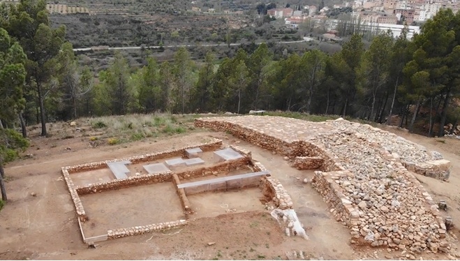
The settlement of La Celadilla de Ademuz is a fortified village from the Iberian period, a little less than half a hectare in size, inhabited between the end of the 5th century and the middle of the 4th century BC, when it was destroyed by a great fire that led to its definitive abandonment and in which some of its inhabitants perished, whose bodies can be found scattered throughout its streets and houses.
It is located on an elongated hill between the spur of the Pico de la Muela and the Barrio de San Roque, opposite the town of Ademuz, at an absolute altitude of between 769 and 774 metres above sea level. It is located on the left bank of the River Turia, at a point where it makes a pronounced meander, dominating at its feet, from a relative altitude of about 70 m., the confluence of this with the River Bohilgues to the west and the Rambla del Val to the east, with the entire irrigated area that currently makes up its valley, so that it visually controls the crossing of the main natural communication routes that cross the Rincón de Ademuz region in a north-south and east-west direction.
Inside you can see some of the rooms of the houses that made up the settlement, in which it has been possible to recover an abundant collection of structures and materials used for food (hearths, ovens, pots, plates, cups, jars), storage (jars, amphorae), agricultural and craft production (sickles, pruning hooks, looms, metallurgical ovens) and personal adornment (rings, necklaces, belt clasps, fibulae). All of this brings us closer to understanding the way of life of Iberian society in a territory considered to be on the border between the Iberian and Celtiberian cultures.
El poblado de La Celadilla de Ademuz es una aldea fortificada de época ibérica, de un poco menos de media hectárea de extensión, habitada entre finales del siglo V y mediados del siglo IV a.C., cuando fue destruida por un gran incendio que supuso su abandono definitivo y en el cual perecieron algunos de sus habitantes, cuyos cuerpos encontramos diseminados por sus calles y sus casas.
Se encuentra emplazado sobre una loma alargada que se sitúa entre el espolón del Pico de la Muela y el Barrio de SanRoque, frente al núcleo urbano de la población de Ademuz, a una altitud absoluta entre 769 y 774 msnm. Se sitúa en la margen izquierda del río Turia, en un punto en que realiza un pronunciado meandro, dominando a sus pies, desde una altitud relativa de unos 70 m., la confluencia de este con el río Bohilgues al oeste y la Rambla del Val al este, con toda la zona de regadío que actualmente conforma su valle, de forma que controla visualmente el cruce de las principales vías de comunicación naturales que atraviesan la comarca del Rincón de Ademuz en sentido norte-sur y este-oeste.
En su interior se pueden observar algunas de las habitaciones de las casas que conformaban el poblado, en las cuales se ha podido recuperar un abundante conjunto de estructuras y materiales destinados a la alimentación (hogares, hornos, ollas, platos, vasos, jarras), el almacenaje (tinajas, ánforas), la producción agrícola y artesanal (hoces, podones, telares, hornos metalúrgicos) y de adorno personal (anillos, collares, broches de cinturón, fíbulas). Todo esto nos acerca al conocimiento del modo de vida de la sociedad ibérica en un territorio considerado fronterizo entre las culturas ibérica y celtibérica.
